Global Warming & the Increasing Frequency of Tropical Cyclones on India’s West Coast
India’s cyclones were largely restricted to her east and northeast coast around the Bay of Bengal. The west coast skirting the Arabian Sea was normally immune, notwithstanding the catastrophic ones in 1976 and 1998. Over the past 5-odd years, however, cyclones are battering the west coast with a terrorizingly increased frequency.
GLOBAL WARMINGCLIMATE CHANGEENVIRONMENTEXTREME WEATHERTROPICAL STORMCYCLONEHURRICANE
Indrajeet Yadav
6/20/20234 min read
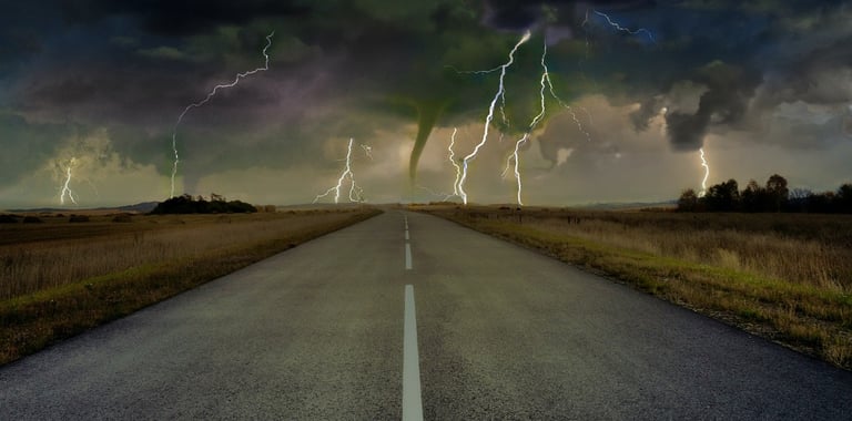
Bolts from the Blue Indian Ocean
They never knew what hit them!
“They” were the 5-odd lakh people in Bangladesh (then East Pakistan) and West Bengal who never woke from their sleep when Cyclone Bhola, the deadliest recorded tropical cyclone till date, made a landfall on the fateful night of 12 November, 1970. Gone with the 185 kmph wind was not just life and property. In part, the storm also swept away Pakistan’s sovereignty over Bangladesh.
Odisha witnessed her worst, 20th century tropical storm in October 1999, which killed thousands and destroyed $4.44 billion worth property. Then came Cyclone Fani in 2019, Orissa’s worst since 1999. It left 89 dead in India and Bangladesh. Damages hit $8.1 billion.
India’s cyclones were largely restricted to her east and northeast coast around the Bay of Bengal. The west coast skirting the Arabian Sea was normally immune, notwithstanding the catastrophic ones in 1976 and 1998. Over the past 5-odd years, however, cyclones are battering the west coast with a terrorizingly increased frequency.
Global Warming and Climate Change are to blame!
So, what is a cyclone? How are cyclones / hurricanes formed? How do they move from sea to land? And why do they destroy anything and everything that dares stand tall in their path?
Tropical Cyclone Formation
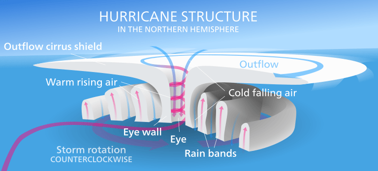
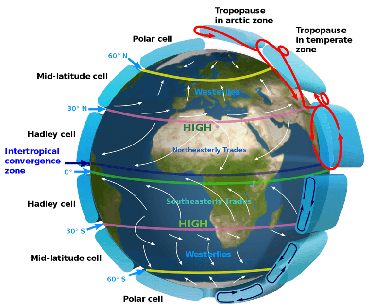
Cyclones are a wind mechanism that rotates anti-clockwise in the northern hemisphere and clockwise in the southern.
Conditions which cause about 95% of cyclones are intense heating of sea surface water to a minimum 26.50C (79.70F) temperature and to at least 50m (160 feet) depth. Heating to sufficient depth supplies the tons of required water, and high temperature evaporates it.
In the first stage of formation, moist and warm air at low pressure rises and diverges forming a low-pressure ‘eye’ at the center. Next, cool air at high pressure gushes in from the neighboring areas creating a system of inward spiraling winds that gets heated up. The cycle continues. Warm, wet air forms clouds as the entire system expands and spirals upwards at growing speed.
Winds with strong vertical gradient deny time for the system to build up momentum – the reason why there are virtually no hurricanes in the South Atlantic. Next, earth’s rotation speed lends them the rotating swirl. Slow rotation speed near the equator means cyclones do not usually form 5 degrees north and south of equator.
Cyclone Trajectory
Tropical cyclone paths can be confusing on account of the multiple driving forces:
Usually, they move with the prevailing winds i.e. from east to west with the trade winds in the tropics.
Coriolis Force moves them pole-wards.
They may interact with other cyclones or the jet stream and change direction.
Agents of Devastation
Torrential rains, storm surge, and catastrophic winds are a hurricane’s three agents of destruction. Rains can hit 2.5cm (1inch) per hour while storm surge raises sea levels, both of which create floods and turbulent streams even as galloping winds uproot homes, trees, electricity poles, and what not.
Rotating around the calm eye of the hurricane is the violent ‘eye wall’ that houses the three agents of disaster. If you are in the path of a cyclone know this: There will be two rounds of stormy rains, one from the eye wall ahead of the eye and another from the trailing eye wall. Don’t let down your guard after surviving the first!
Weakening & Death of Cyclone
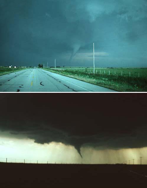
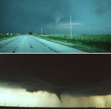
When a cyclone moves to cooler land or water, the heat source which creates and sustains it is no longer available, and it dies away. Cyclones may converge cold and hot air. Cold air pushes up and swirls the hot air to form a funnel cloud, popularly called a tornado.
Due West Coast: The Wrath of Tropical Cyclones in India
Warmer waters of the Bay of Bengal made it the conventional hot spot for cyclone formation. Prevailing east-to-west trade winds then transported them to India’s east coast. The Arabian Sea was normally “cyclone shy” because of its cooler waters. Those that were formed were taken to Yemen or Oman by the prevailing trade winds.
Global Warming and Climate Change are transforming this.
Higher surface water temperatures are irritating the cool Arabian Sea into generating more cyclones. And the complex mechanisms involved in their motion means they can move east and hit the west coast.
With escalated evaporation due to higher temperatures, the frequency, intensity, and distance travelled by cyclones before dissipating are all surging upwards. And this applies to all cyclones across the globe.
However, scientists are also improving weather forecast and better predicting hurricane trajectories. There are live cyclone trackers as well. Such developments have minimized damage to life and property. Forewarned truly is forearmed. But then, prevention (of global warming) is better than cure! Moving ahead, we need a bit of both.
Falcon Words offers stellar content on environment issues by linking developments to the fundamentals. Write to us at indrajeety1981@gmail.com or call us at +91-98220-52945 for content tailored to your specific requirements.
#GlobalWarming #ClimateChange #TropicalCyclones #India #CoastalSafety #EnvironmentalImpact
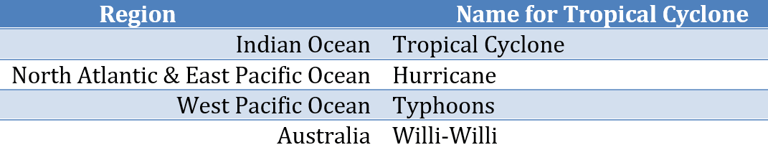

Names for Tropical Cyclones in Different Regions
Tropical Cyclone Formation in North Hemisphere
Credits Kelvinsong at Wikipedia
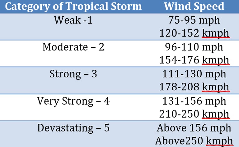
Saffir-Simpson Scale on Cyclone Intensity
Pressure Belts & Planetary Winds
Credits Kaidor at Wikipedia
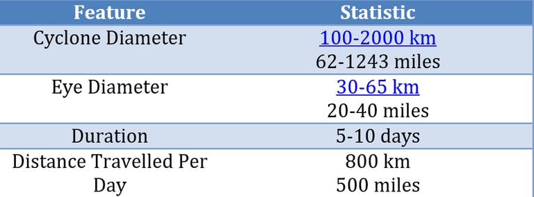
Cyclone in Average Statistics
Waurika, Oklahoma Tornado, 1976
Credits David Hoadley & NSSL at Wikipedia
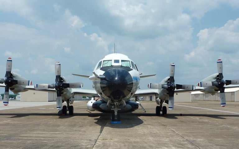
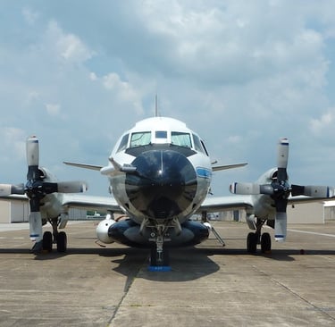
NOAA’s Purpose-built Aircraft to Capture Data at the Eye of the Storm
Credits obz3rv3r at Flickr